With another day came another trip to the grocery store for a few more final items, but this time we went north (or is it east?) to Tavernier rather than south/west to Marathon. The remainder of the day was spent helping prepare dinner and relaxing at Paz's beautiful vacation rental.
Tropical trio of Keeley, Anna Lee and Brayden. Did you ever eat the coconut we retrieved from the palm tree?

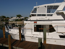
Paz, Susan, Carl, Michele and the girls, Keeley and Brayden. Thanks so much for all your hospitality!

On Sunday we travelled about seven hours to Angelfish Creek. We scoped out Angelfish Creek but it was a little narrow for anchoring, so we decided to anchor on the north side of an island between the Angelfish Creek channel and Pumpkin Key. The wind was supposed to be out of the southeast all night so we thought we would be pretty well protected.
About 8:30 that evening a storm blew through with a fair amount of lightning, wind and rain but we were on the outer edge of the watch box and by 9:30 it had essentially passed us by. About 2:30 a.m. we were awakened by wind and waves and were unable to go back to sleep so we got up. Shortly after that a very nasty storm hit us full force with north (not southeast, as predicted) winds well over fifty miles per hour and blinding, pounding rain.
The only thing we could see was the red blinking channel marker for the entrance to Angelfish Creek which seemed to be much closer that it had been when we anchored. Todd decided that we must be dragging anchor so he started the engines and tried to motor into the wind to relieve some of the pressure on the anchor and chain; however, it was too little, too late. By the time I got the navigation software and GPS up and running to see where the boat was in relation to our surroundings, it showed that we were virtually on top of the island near which we had anchored. I grabbed a flashlight to look out the sundeck and, sure enough, we were right on top of the mangroves!
Within a few seconds we drifted into the mangroves and immediately shut down the engines. At that point we were aground and could do nothing further, and we knew we weren't going anywhere, so we went back to bed at 5:30 a.m. hoping to get a few hours of sleep. The tide was still pretty low when we got up Monday morning but we knew it would be rising until about noon so we employed whatever means we could think of to pull the boat off. We got the dinghy down and tried using an extra anchor off the starboard side for leverage but the anchor wasn't big enough and didn't hold well enough to gain any ground. Todd also tried using the dinghy to pull the bow of the boat around, but the engine just didn't have enough horsepower to do us any good.
The morning after the night from hell. Todd works the rope in hopes of pulling "Life's2Short" out of the mangroves... right!

Thankful for the morning after. No damage other than some frayed nerves.


In the end we finally got the bow to swing around, with a little help from the bow thruster and the rising tide, by pulling in the slack in the anchor chain, which was at a ninety degree angle to the bow. When I got to the anchor it had a whole mess of rope and seaweed wrapped around it which, I'm sure, didn't help our situation during the storm. Nonetheless, we were free and when the Captain dove under the boat to check for damage, everything appeared to be in good working order. So other than a few incredibly stressful hours during the night, we were, thankfully, unscathed.
At that point we consulted our cruise guide and decided to go north to Boca Chita Key which is part of the Biscayne National Park. There are no services (not even a trash dumpster) and they don't allow pets, but there is plenty of space to dock boats around the perimeter of the harbor and after the ordeal of the previous evening, we were more than happy to pay the $20 per night dockage fee! Boca Chita is an absolutely beautiful place; its only downside were the mosquitoes and no-seeums that virtually ate us alive every time we left the boat!!!
A gorgeous sunset at Boca Chita.

Boys and their toys. The Miami Dade Fire Rescue conducts a drill on Boca Chita.

We stayed at Boca Chita two nights and George & Mary aboard "Love Knot" joined us about 3:30 the second afternoon. We had seen George & Mary in Ft. Myers Beach and knew they were planning to be in the vicinity so we called and let them know our plans, hoping to meet up with them again along the way. After a nice lasagna dinner that evening, with wine and dessert provided by George & Mary, we all watched American Idol before retiring for the evening.
Another wonderful sunset at Boca Chita.


"Love Knot" pulled out shortly before 8:00 Wednesday morning and we left a couple of hours later to go to No Name Harbor, a popular anchorage just southeast of Miami. No Name Harbor is part of the Bill Baggs Cape Florida State Recreation Area at the southernmost tip of Key Biscayne. It is also very pretty, pets are allowed and for $15 per night you have access to an on-site restaurant, ice, laundry (one washer, one dryer), trash and free pump-out.
The entrance to Bill Baggs Cape Florida State Recreation Area.

The view of No Name Harbor from the Boaters Grill.

On Thursday we walked down to the lighthouse at the tip of Key Biscayne and trudged up the 118 spiralling steps to the top, which offered a spectacular view of the Atlantic! After our excursion we stopped at the restaurant for a quick burger before returning to the boat. I then did a load of laundry while Todd worked on replacing the float in our shower sump which had stopped working for some unknown reason.
A Great Blue Heron with "Stiltsville" in the background. "Stiltsville" is a group of formerly private homes built in shallow water quite some distance off shore. As you might imagine, most have been destroyed by hurricanes.

The Cape Florida lighthouse at the southern tip of Key Biscayne.

The lens room at the top of the lighthouse.

A view of the lighthouse keeper's cottage and cookhouse from near the top of the lighthouse.

This shot of one of the nation's top ten beaches was also taken from the lighthouse. Miami's South Beach is in the background.

We walked about a mile to town this morning to get a few things at the grocery store and then I did another load of laundry while writing the blog update. The weather is looking good for crossing the Gulf Stream tomorrow so we will likely be up and on our way shortly after sunrise in the morning, barring any further unforeseen difficulties!
The forecast is calling for another front to move through from the north by Sunday evening, so we are considering going to the Bimini Islands tomorrow and staying there until the front passes rather than tackling the three-day journey to Nassau (Key Biscayne to Gun Cay; Gun Cay to Chub Cay; Chub Cay to Nassau). We have been talking to a couple on a sailboat in the harbor who are telling us that we shouldn't bypass an opportunity to see the Bimini Islands and Alice Town so that may be a good option for us under the circumstances. At any rate, our "plan" is to head out in the morning so, once again, please keep us in your thoughts and prayers as we venture out into the deep blue ocean!
1 comment:
come back and get me, I'm tired of the rain. Todd the rock was over 933 on Sunday and the Bull is now 41 over. George
Post a Comment